|
Dale Stenseth's Arizona High Point Page
| |
Highpoint 42. Arizona, Humphreys Peak, 12,633 ft, 10/21/04
Humphreys Peak is located about 14 miles north from Flagstaff.
My ascent time was about 4 hours, 15 minutes. Descent was about 3 hours. The road to the trail-head at the Arizona Snowbowl is rental car "safe" (paved), if you are not in blizzard conditions as we were on the descent. The parking lot is gravel.
Used Wingers' book and Zumwalt's book for guidance. See comments below.
This was my most dangerous ascent so far, because of the weather and wind conditions. Northern Arizona was struck by an early winter storm. In Yosemite, 2 Japanese climbers died and many hikers were stranded by the same weather system. Flagstaff had a record breaking 5-1/2 inches of snow later in the day. We knew the system would cross the summit at mid-day and had planned to be on our way down by then.
I like to hike solo so I can set my own pace. On this trip, my nephew and his dad came along. They both did very well.
We departed from the Snowbowl trail-head at 7:45 am. There is a trail-register about 1 mile from the trail-head. There had been 3 parties the previous day. We were the only group listed for this day, as of the time we logged out.
Most of this trail is not steep. Many sections seem to be nearly horizontal for long distances. The trail could easily be shortened by a mile. Also, some guide books show a few long switchbacks on the trail. There are many more switchbacks than shown.
Rain or sleet fell during the first half of the ascent. After that, there was snow and sharp, wind-blown ice bits. The area below the saddle had ice on the rocks. There are some trees almost all the way to the saddle, but they become very small and sparse.
We reached the saddle at 10:45. The distance from the saddle to the summit is about 1 mile. It was difficult to follow the trail in the snow going up, but easy to follow going down. From the saddle on, the winds were gusting to 60 mph (my estimate). It was unusual in that the gusts would come from either direction. At about 12,400 feet, my companions could go no further, and hunkered down for 40 minutes, while I continued another 1/3 mile to the summit and returned.
I estimate the winds at the summit were gusting to 100 mph, but were more consistent in direction. I was literally blown down to the ground several times, and was blown uphill at times. I knew I might have to, and was prepared to, crawl down from the summit on my hands and knees. When I reached the large stone cairn shelter wall at the summit, I tumbled into it with help from the wind gusts at my back. Many thanks to whoever build that shelter-cairn, which provided a respite from the wind. I wanted to stay a while longer, but it was cold and I had to get back to my companions. At this point, my total focus changed to getting to lower elevation quickly and bringing us all back alive.
While the conditions were almost white-out, I saw no post at the summit, as referenced in some guide books. Because the summit was covered with snow, I did not see or look for either an ammo box, or benchmark survey markers.
My Olympus camera would not take pictures in the cold at the summit. My trusty Garmin eTrex Legend GPS worked without fail, recording a track from the tree line to the summit. It just doesn't work where there is tree cover. I also recorded a way-point at the summit, and had earlier recorded way-points at the trail-head, the saddle, and where my companions were waiting.
We saw an abandoned or lost Camel-back sticking out of the snow on the upper ridge above the saddle, and would have packed it out under other conditions. It might have to wait until spring.
We were back to the saddle by 12:45 pm and descended as fast as the ice would allow. By this time, our water and Gatorade was slushy or frozen. Some of our food was pretty stiff.
We saw no one on the ascent, and only 2 other people on the descent. One was a jogger who turned around when she met us. The other was a solitary hiker, headed somewhere into the storm.
Wet heavy snow had accumulated at the trail-head. Our vehicle was a Dodge Stratus 2 wheel drive. The road was so slick, we slid off on one corner, but were able to back out. Met stalled 4WD vehicles trying to go up. The start of the road had been posted '4WD or chains only' by the time we got back to Hwy 180.
Equipment:
I knew it would be snowy, cold, and windy. Wore a stocking cap instead of a Gilley's hat. Wore wicking thermal underwear, wicking wool-blend socks, and a flannel shirt. Wore a breathable hooded shell and rain pants. Boots worked ok. Insulated leather gloves are great if there is any scrambling. The leather was wet by the end of the hike. Except for biting wind-blow ice in the face, I was mostly warm, comfortable, and dry. A hiking pole was vital. Wished I had cramp-ons. Bought them the next day at Grand Canyon Market Plaza.
Electronic gear included camera, GPS and Suunto watch-altimeter-barometer-compass. I'm afraid this will be the last cold weather trip for my Olympus camera. It would not work in the cold at the summit.
Our subsequent plan was to hike the Grand Canyon South Rim 2 days later. My companions hiked out to Plateau Point (12.2 miles RT and 3000 ft.). I caught a bad cold and was not able to do any serious hiking. I had wanted to hike to the suspension bridges and back in one day, but that will wait until spring.
|
|
| Description |
Picture |
Two days later, on our return from the Grand Canyon, the sky was clear and Humphreys Peak could be seen from far away.
Humphreys Peak is on the left.
Agassiz Peak is on the right.
Note the false summits between the saddle and Humphreys Peak.
The distance from the saddle to the summit is around 1 mile. |
 |
Snow monsters below the saddle.
|
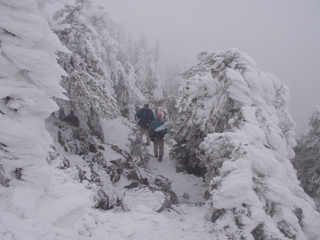 |
Near the saddle.
|
 |
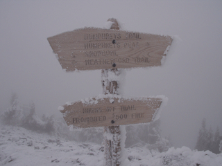
We had to chip off the ice to read the signs.
|
 |
Copyright © 2004-2006 Dale Stenseth. All rights reserved.
This page may be freely linked to, but may not be duplicated in any manner without the author's express consent,
except that hikers may print a single copy of trip reports for personal use.
|